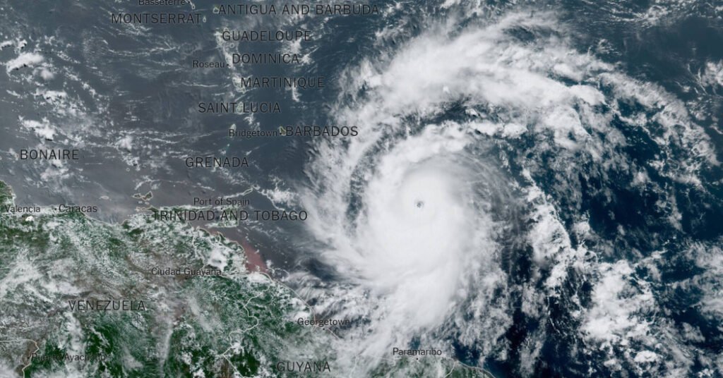
Beryl strengthened into a record-breaking Category 4 hurricane on Sunday, the soonest a storm has reached that level of strength this season, and forecasters warned that it would continue to intensify rapidly as it moves westward toward the Caribbean.
Before Beryl, the oldest recorded Category 4 hurricane was Hurricane Dennis on July 8, 2005.
The National Hurricane Center said Sunday that Beryl, the first hurricane of the 2024 season, is expected to bring “life-threatening strong winds and storm surge” to the Windward Islands southeast of Puerto Rico and north of Venezuela.
By Sunday afternoon, sustained winds had reached 130 mph, making it an “extremely dangerous” Category 4 hurricane, forecasters said.
Hurricane warnings were issued for Barbados, Saint Lucia, Saint Vincent and the Grenadines, Grenada and Tobago, while tropical storm watches were in effect for Martinique and Trinidad, and tropical storm watches were in effect for Dominica and parts of the Dominican Republic and Haiti.
Life-threatening strong winds and storm surges were expected in the Windward Islands beginning early Monday morning. The National Hurricane Center made the announcement Sunday morning..
A study published last year found that Atlantic hurricanes are now twice as likely to go from a weak storm to a Category 3 or greater hurricane in just 24 hours.
The damaging winds from Beryl occur where the eyewall, the area surrounding the eye of a hurricane, crosses the islands, and the winds can be even stronger in the higher elevations of the islands’ hills and mountains.
Beryl is the third-earliest major hurricane to form in the Atlantic, according to Philip Klotzbach, a seasonal hurricane forecaster at Colorado State University. Only two hurricanes have formed earlier in the calendar year: Alma on June 8, 1966, and Audrey on June 27, 1957.
Both hurricanes made landfall on the U.S. coast in the Gulf of Mexico: Alma near St. Marks, Florida, and Audrey near Port Arthur, Texas.
Beryl reached tropical storm strength late Friday with sustained winds of 39 mph. If it reaches 74 mph, the storm will become a hurricane.
Here are some important things to know about the storm:
Forecasters said swells generated by Beryl were expected to reach the Windward and southern Leeward Islands by late Sunday, bringing potentially life-threatening rough seas and low tides.
The storm is expected to move across the eastern Caribbean islands as early as Sunday night, then across the central Caribbean through mid-week.
Between 3 and 6 inches of rain, hurricane-force winds and dangerous storm surges are possible for the eastern Caribbean islands, including Barbados, and St. Vincent and the Grenadines, from Sunday into Monday.
Countries prepare for Beryl.
Grenada’s Prime Minister Dickson Mitchell said the country would be under a state of emergency from 7pm on Sunday.
He said that with the exception of police and essential workers, “everyone is expected to stay at home or in a shelter.”
St. Vincent and the Grenadines Prime Minister Ralph Gonsalves, in a national address on Sunday, said many buildings were at risk of losing their roofs and urged residents to take the storm seriously.
“Some people are hoping for the best, and we have to do that too,” he said, “but we also have to prepare for the worst.”
The Prime Minister ordered people to stay in place from 7pm on Sunday. Emergency shelters were due to open at 6pm on Sunday.
In St. Lucia, Prime Minister Philip J. Pierre announced a nationwide lockdown effective at 8:30 p.m. Sunday, with schools and businesses remaining closed on Monday.
In Barbados, two flights to London were the last international flights to depart from Grantley Adams International Airport on Sunday evening before the airport was closed. Tourism officials said visitors to the island would be welcomed at government-designated evacuation centers, which are scheduled to open at 6 p.m. on Sunday.
This upcoming hurricane season is expected to be a busy one.
Forecasters are warning that the 2024 Atlantic hurricane season could be much more active than usual.
In late May, the National Oceanic and Atmospheric Administration predicted between 17 and 25 named storms would form this year. This is an “above normal” figure and is in line with more than a dozen predictions made earlier this year by experts from universities, the private sector and government agencies.
On average, hurricane season produces 14 named storms.
What made the seasonal hurricane forecast especially grim was that forecasters looking ahead to the start of the season were predicting a combination of conditions not present in records going back to the mid-1800s: record-warm Atlantic waters and the potential for the formation of a weather pattern known as La Niña.
A strong La Niña often brings calm conditions to the Atlantic Ocean, allowing storms to develop more easily and intensify without being hindered by wind patterns.
Johnny Diaz, John Yoon, John KeeffeKenton X. Chance, Julius Gittens, Sherfil Gaillard, Linda Straker, Yang Zhuan Contributed report.

