
The GOES-16 and Sentinel 3 satellites recorded the April 8 solar eclipse across North America and studied its impact on weather patterns. Credit: ESA, Data: NOAA
On April 8, a total solar eclipse darkened parts of North America and was captured by GOES-16, providing insight into the atmospheric effects.
On April 8, a total solar eclipse struck all of North America, momentarily blocking out the sun and plunging parts of the continent into darkness. A geostationary satellite orbiting 36,000 km (22,000 miles) away captured images of this rare celestial phenomenon.
These images, taken by the Geostationary Operational Environmental Satellite (GOES-16), capture the moon’s shadow as it moves across North America from about 10 a.m. to about 5 p.m. EDT (16:00-23:00 Central European Time)
A total solar eclipse occurs when the moon passes between the sun and the Earth and briefly blocks the face of the sun, except for a visible ring of light known as the sun’s corona.
The path of the moon’s shadow across the Earth’s surface, known as the Total Path, stretched across the North American continent from Mexico to the easternmost tip of Canada.
The GOES series is a joint development and acquisition effort between the National Oceanic and Atmospheric Administration (National Oceanic and Atmospheric Administration).NOAA) and NASA. The first satellite in the series, his GOES-16 (GOES-East) satellite, will provide continuous images and atmospheric measurements of the Earth’s Western Hemisphere and monitor space weather.
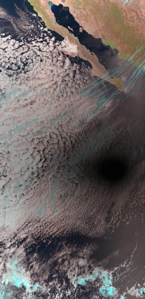
On April 8, a total solar eclipse struck all of North America, momentarily blocking out the sun and plunging parts of the continent into darkness. The Copernicus Sentinel 3 mission used the Sea Land Surface Temperature Radiometer (SLSTR) to image the eclipse. This image was captured at 19:45 CEST (17:45 UTC).Credit: Contains modified Copernicus Sentinel data (2024) processed by ESA
The Copernicus Sentinel 3 mission also took images of the solar eclipse (see above) using the Sea Land Surface Temperature Radiometer (SLSTR).
Solar eclipses also serve as a laboratory for studying what happens to the weather when the moon’s shadow passes. Shadows can lower temperatures and cause clouds to develop in different ways. Data from GOES, Sentinel-3, and other satellites are currently being used to investigate these effects.